Roughly half of California's population lives in southwest California, concentrated in a coastal megalopolis stretching from Santa Barbara to San Diego. At its antipode in northeast California's Modoc County is a vast volcanic landscape, in which cattle far outnumber people.
Besides a dozen hamlets too small for traffic lights, there's the county seat of several thousand people, Alturas. Here you'll find no malls, no auto row, no fast-food establishments, no subdivisions, and no air pollution -- just pure, untrammeled Americana.
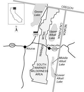
If you want to get away from it all, this place is for you. Alturas is a distant 140 miles from the city of Redding via eastbound Hwy. 299, and 185 miles from the city of Reno via northbound Hwy. 395. Where the two highways meet -- at the north end of Alturas -- is the locus for trailhead directions in the Warner Mountains.
The Warner Mountains are California's northeastern most range, separating the Modoc Plateau to the west from the Great Basin to the east. Bearing affinities to both geologic provinces, it's composed of multiple, thick lava flows like the Modoc Plateau, and is a dipping fault-block range like those of the Great Basin.
The Surprise Valley fault system trailing the Warner's eastern escarpment is the principal site of still-active faulting here. The system is stretching the land, causing Surprise Valley to sink over time.
Today it is filled with deep sediments capped by three large, muddy and extremely shallow Upper, Middle, and Lower Alkali lakes. Thinning of the crust has allowed magma to work toward the surface here, heating ground water and giving rise to a string of hot springs, which parallel eastside County Road 1.

Surprise Valley, Alkali Lake, Cedarville from north end South Warner Wilderness
About 12 miles north of Cedarville, County Road 13 branches east from it toward nearby mud volcanoes, which have erupted and steamed away in historic time. Indeed, after the hamlet of Cedarville, civilization ends.
Highway 299 heads 9 miles east of it to the Nevada border, where a dirt road, with a dire warning on lack of services, carries onward. We Californians tout our Sierra wildernesses that are, really, not as wild or as remote. For wilderness, northwestern Nevada and this less traveled corner of California are some of the most remote areas in the Lower 48.
Highway 299 bisects the Warner Mountains, the lower elevation northern half of which is traversed by roads and the higher elevation southern half is traversed by trails. This roadless area features the 70,385-acre South Warner Wilderness.
The west-dipping range is a miniature Sierra Nevada, and just as the southern part of that range is highest and mostly roadless with the north-trending John Muir Trail along its crest, so the South Warner Wilderness has the Summit Trail.
The Summit Trail doesn't take you to the Warner's highest mountain, 9,892' Eagle Peak but it gives you access to "lowly" 8,646' Squaw Peak, just off the Summit Trail's northern section.

Squaw Peak from Summit Trail, South Warner Wilderness

Squaw Peak from Summit Trail, South Warner Wilderness
Should you have to "bag" Eagle Peak, you can reach it by either taking the Slide Creek Trail from Soup Spring Campground or the Poison Flat Trail from Mill Creek Campground. Both lead east to the Summit Trail, but where the first reaches it you'll ascend the peak's northwest ridge, and where the second reaches it you'll ascend its southwest ridge.
The guidebooks Backpacking California and 101 Hikes in Northern California from Wilderness Press include the area. Wilderness Press's South Warner Wilderness guidebook is out of print.
Information is available on the Modoc National Forest website. A topographic South Warner Wilderness Map can be purchased here.
Like the Sierra Nevada the Warner Mountains has lakes. But rather than occupying glacier-excavated basins, about half the lakes lie uniquely behind or atop massive rockfall deposits.
Along the Pine Creek Trail you can visit three such lakes found in this drainage. The two largest rockfall-dammed lakes are Clear Lake, just east of Mill Creek Campground, and, south of the wilderness, 0.75-mile-long Blue Lake.
The range is one of the few areas to harbor all three of California's yellow pines; ponderosa, Jeffrey, and the relatively rare Washoe. These grow at lower elevations -- Mill Creek Campground is a classic site --- but as you ascend you'll encounter white fir, western white pine, lodgepole pine, and finally whitebark pine.
Conspicuously absent is red fir, a conifer common to the Klamath Mountains, Cascade Range, and Sierra Nevada. On drier slopes grow lots of sagebrush plus lesser amounts of mountain mahogany, mule ears, and western juniper. In localized areas with sufficient groundwater, aspens grow in tight clusters and, in late summer, add yellow dabs of color to the landscape.
In mid-June 1996, I visited the South Warner Wilderness. Seems I was about two weeks early for my planned 40 mile loop trip. That's okay, my body wasn't ready for that anyway <grin>. I was able to drive to the Modic National Forest Pepperdine Campground - free - outhouse and spring water system, free cut and split firewood. Part of the reason for this I think, was the fact that they have had trees dying and have cut them to keep from falling on tourists. Had the campground all to myself.
I did a 10 mile round trip day hike on the "Summit Trail" into the South Warner Wilderness. Some great scenery. I had some snow patches but all easily negotiated. I got to within 1/4 mile of Cottonwood Lake when the snow got heavier and I was tired. If I'd had overnight gear I could have made it. Of course, the lake might have been frozen.

South Warner Wilderness from Forest Road 31

Elephant Ears along Summit Trail, South Warner Wilderness

Tom Lee Meadow, pond, house from north end South Warner Wilderness

View along east side of crest on Summit Trail from saddle - Devil's Knob, Warren Peak, South Warner Wilderness

Devil's Knob from Summit Trail, South Warner Wilderness

Warren Peak from Summit Trail, South Warner Wilderness

Warren Peak from Summit Trail, South Warner Wilderness

Warren Peak from Summit Trail, South Warner Wilderness
The next day I drove to the Pine Creek Trailhead and took a four mile round trip hike to Pine Creek Basin. Nothing spectacular, but a nice hike - grassy meadow and some small lakes.
Earlier in the day I had talked to a local from Alturas who had flown over the area the day before and he said Patterson Lake (larger than Cottonwood but nearby) was still frozen.

Meadow below Pack Station at Pepperdine Campground
at north edge of South Warner Wilderness

View over pond in Pine Creek Basin on west side of South Warner Wilderness

Creek and meadow in Pine Creek Basin on west side of South Warner Wilderness

Pine Creek Basin on west side of South Warner Wilderness

Lake along Pine Creek trail on west side of South Warner Wilderness

Meadow and creek on Pine Creek trail on west side of South Warner Wilderness

Clear Lake, not clear, lots of algae, typical lake turning into a meadow, on west edge of
South Warner Wilderness
The following morning I drove around to the Modoc National Forest Mill Creek Falls Campground, hiked up to Mill Creek falls (a nice falls with a rainbow) then on up the trail to Clear Lake (not clear - lots of algae - typical lake turning into a meadow). Total hike under 2 miles round trip.

Mill Creek Falls on west edge of South Warner Wilderness

Rainbow at Mill Creek Falls on west edge of South Warner Wilderness