May 1915 Eruption of Lassen Peak
Check the following PDF files for more information:

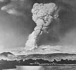
On the night of May 19, 1915, the few people homesteading outside of Old Station along Hat Creek near the foot of Lassen Peak, a volcano in northern California, went to bed expecting a peaceful night’s sleep. By now they had become accustomed to the sounds of small steam explosions coming from the volcano, which had been intermittently active during the past year.
Around midnight, Elmer Sorahan was awakened by his dog barking furiously and pawing him. Dressing quickly, Elmer went outside, expecting a bear or other animal.
Instead, he dimly saw a 12-foot high wall of muddy water and logs rumbling down Hat Creek. After running more than a mile to warn his downstream neighbors, the Halls, he burst through their front door exhausted and shouting "Get out! get out! there’s a flood coming." Mrs. Hall quickly spread the alarm downstream by telephone, and then the family scrambled uphill just before the house was swept off its foundation.
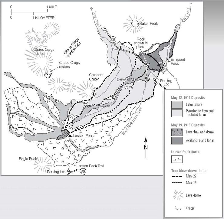
The next morning residents of the area saw that a wide swath of the northeast slope of Lassen Peak had been devastated by a huge avalanche and mudflow triggered by a powerful explosion at the volcano’s summit.
Fortunately, because of the warnings, no one was killed, but several houses along the creek were destroyed.
For more information see my 2008 Trip Page.
When Lassen Peak erupted again on May 22nd, the area was further devastated by a high-speed flow of hot volcanic ash and gas (called a "pyroclastic flow"), and the incorporation of snow into this flow generated new mudflows. Ash from the eruption rose high into the air and wind blew it eastward. Fine ash fell at least as far as 200 miles from the volcano.
Because of the eruptive activity, which continued through 1917, and the area’s stark volcanic beauty, Lassen Peak and the area surrounding it were declared a National Park in 1916.
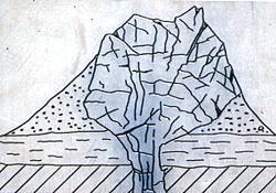
Lassen Peak, 10,457 feet above sea level, is the largest plug dome volcano on earth.
On May 30, 1914, Lassen Peak erupted into a phase of volcanic activity which lasted three years. Not until 1917 did activity cease, and the mountain entered into its present state of dormancy. Only steam vents and the odor of sulphur atop the summit give hint to the eruptive potential of the mountain.
The plug dome is formed when a mass of relatively cool and pasty lava is pushed upward out of a vent. This is as one would squeeze toothpaste out of a tube. The thick lava piles up, cools, and hardens into a huge plug of volcanic rock.
Chaos Crags is also a plug dome volcano, formed recently, perhaps 300 years ago.
My first visit to Lassen was a backpack trip in 1975. Thirty-three years later I visited again on a day trip in 2008.
1975 Backpack Trip
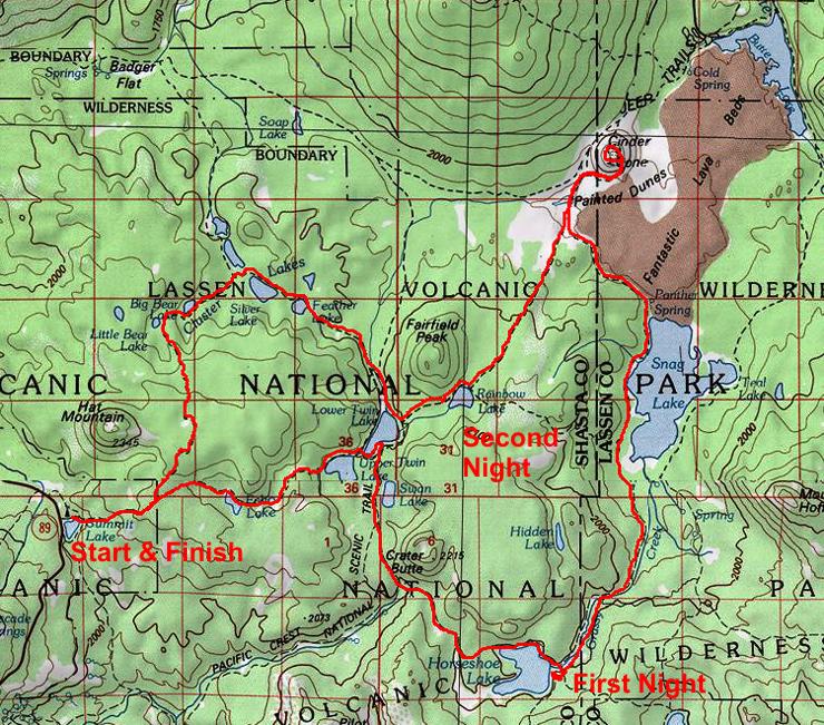
On September 6-9, 1975, myself, Stan Haye, Gil Bielke, Scott Morton, Mic Mead and Tim McSweeney gathered at the Park for a backpack trip.
We would climb 6,907' Cinder Cone and 10,457' Lassen Peak and hike 35 miles total.
On Friday, September 5, Gil came out of the mountains with Brian Jordan and cleaned up at my apartment in Lone Pine. Brian's folks came and they left on vacation.
Scott and Mic came up from San Diego - had car trouble near Little Lake and arrived late - finally fixed car about 8 p.m.
We transferred to Stan's car in Independence and proceeded north along with Mic who would later go on to Idaho.
Tim met us at the park. We made camp at Frenchman Flat Recreation area about 63 miles south of Susanville around 3 a.m.
Got up at 7 a.m. or so and made it into the park around 11 a.m. After lunch we hit the trail from north Summit Lake campground around 12:30 and traveled through forest with one view of Lassen Peak to Echo Lake, upper & lower Twin Lakes, Swan Lake and finally to Horseshoe Lake where we camped about 5 p.m. in an improved campground - formerly a car camp.

Horseshoe Lake and Lassen Peak
Sunday we broke camp leisurely and left about 9 a.m. following a pretty stream to Snag Lake - large and nice. Then on to the Cinder Cone trail junction (missed Panther Spring somewhere). Tim had not been well the night before and Mic was having knee problems so they went on to camp at Rainbow Lake while Gil, Scott, Stan and I took the trail to the top of Cinder Cone.
We had fine views of Butte and Snag Lakes, the Fantastic Lava Beds and Painted Sand Dunes - and nearby peaks and forest. The ice cave on the trail down was not much - no ice - just a vent hole with cold air.

Rainbow Lake

Lassen Peak
We all arrived at Rainbow Lake around 4:30 and after a swim fixed supper. Our camp was visited a number of times by four deer.
Monday we proceeded via Twin Lakes to Feather, Silver, Big and Little Bear Lakes in the Cluster Lakes area.

Silver Lake
Gil, Scott and Tim arrived back at Summit Lake early and toured Bumpass Hell. Mic, Stan and I took it more leisurely and arrived about 3 p.m. - went for gas and toured the northerly sights along the road. We all gathered about 5 p.m. at campsite A-16 in the North Summit Lake Campground.
Tuesday morning we got up early - 6 a.m.-and after breakfast drove to Lassen Peak trailhead and hit the trail under cloudy skies about 7:45. I made the 2.5 miles to the top in 1.5 hours.
It was cold and windy but not raining. The views were screened by haze and clouds but you could see the area fairly well including Mt. Shasta.

Bumpass Hell
Mic, Stan and I toured the old crater areas before heading down. On the way down it sprinkled some as the storm seemed to be blowing past the area.
Back at the cars around 11 a.m. Mic headed for Idaho, Tim for home, and the rest of us went to Bumpass Hell to see the steam vents and mud pots.
We then made a short stop at the Sulphur Works and the cafeteria at the ski area - finally getting on the road for home about 3 p.m.
We stopped in Reno for gas and Carson City for supper about 7 p.m. We hit heavy rain around Bridgeport which slowed things down a little. The drive down Owen's Valley featured a wild electrical storm. We arrived home about midnight
Gil and Scott spent the night and headed for San Diego around 6 a.m. Wednesday. I enjoyed the trip. The hike through the forest wasn't too impressive and it would be nice to spend more time in the southern end of the park around Lassen Peak and Warner Valley.

Lassen Peak from the North

Summit Lake

Summit Lake

Summit Lake

Lassen Peak from Echo Lake Trail

Echo Lake

Upper Twin Lake

Upper Twin Lake

Lower Twin Lake

Lower Twin Lake

Swan Lake - Crater Butte

Horseshoe Lake

Horseshoe Lake
Horseshoe Lake and Lassen Peak

Meadow between Horseshoe Lake and Snag Lake

Lassen Peak reflected in Horseshoe Lake

Snag Lake

Snag Lake

Snag Lake

Lava Flow which formed Snag Lake

Fantastic Lava Beds

Cinder Cone - Fantastic Lava Beds

Cinder Cone

Nobles Emigrant Trail near Cinder Cone

Volcanic Bombs at Cinder Cone

Cinder Cone - Lassen Peak in the haze

Lassen Peak from Cinder Cone

Cinder Cone

Cinder Cone

Snag Lake from top of Cinder Cone

Snag Lake from Cinder Cone

Snag Lake from Cinder Cone

Butte Lake and Fantastic Lava Beds from Cinder Cone

Butte Lake from Cinder Cone

Painted Dunes, Fantastic Lave Beds, Snag Lake and trail from Cinder Cone

Painted Dunes from Cinder Cone

Painted Dunes from Cinder Cone

Painted Dunes from Cinder Cone

Cinder Cone and Fantastic Lava Beds
Rainbow Lake

Deer at Rainbow Lake

Deer at Rainbow Lake

Rainbow Lake

Lower Twin Lake

Feather Lake

Feather Lake
Silver Lake

Silver Lake and Lassen Peak

Silver Lake

Unnamed lake in the Cluster Lakes

Unnamed lake in the Cluster Lakes

Big Bear Lake

Lassen Peak from the trail

Lassen Peak from the trail

Chaos Crags

Lassen Peak and Devastated Area

Mic Mead at Lassen Peak trailhead

Helen Lake and Brokeoff Mountain from Lassen Peak trail

Warner Valley from Lassen Peak trail

Brokeoff Mountain and area west of Lassen Peak from trail

Helen Lake from Lassen Peak trail

Lassen Peak
Top of Lassen Peak

Helen Lake and trail from Lassen Peak

Mountain Mouse on top of Lassen Peak

Devastated Area from Lassen Peak

Craters and crags on Lassen Peak

Among Lassen Peak craggy top

Craters and crags on Lassen Peak

Crater on Lassen Peak

Lassen Peak crags

Vent on Lassen Peak

Helen Lake and Brokeoff Mountain from Lassen Peak trail

Lake Amador in distant haze from Lassen Peak

Lassen Peak from Helen Lake

Brokeoff Mountain from Bumpass Hell trail

Brokeoff Mountain from Bumpass Hell trail

Bumpass Hell
Bumpass Hell

Steam vent at Bumpass Hell

Mud Pot at Bumpass Hell

Steam vent at Bumpass Hell

Bumpass Hell

Boiling springs at Bumpass Hell

Mud Pot at Bumpass Hell

Bumpass Hell

Boiling Spring at Bumpass Hell

Boiling Spring at Bumpass Hell

Boiling Spring at Bumpass Hell

Boiling Spring at Bumpass Hell

Bumpass Hell

Bumpass Hell

Brokeoff Mountain from Bumpass Hell trail

Brokeoff Mountain from road

Brokeoff Mountain from road

Sulphur Works
Hiking Bumpass Hell - National Park Service
| LASSEN VOLCANIC NATIONAL PARK - THREE DAY BACKPACK | ||||||
| Itinerary | Elevation | Miles Between Points | Miles From Start |
Miles Today | Grade Feet Per Mile |
Elevation Change |
| FIRST DAY | ||||||
| North Summit Lake Campground | 6700 | 0.0 | 0.0 | 0.0 | -- | -- |
| Trail Junction | 6700 | 0.2 | 0.2 | 0.2 | 0 | 0 |
| Trail Junction | 7150 | 0.9 | 1.1 | 1.1 | 500 | 450 |
| Echo Lake | 6950 | 0.9 | 2.0 | 2.0 | -222 | -200 |
| Upper/Lower Twin Lake Tr. Junct. | 6537 | 1.8 | 3.8 | 3.8 | -229 | -413 |
| Trail Junction | 6537 | 0.1 | 3.9 | 3.9 | 0 | 0 |
| Trail Junction near Swan Lake | 6700 | 0.7 | 4.6 | 4.6 | 233 | 163 |
| Trail Junction-Grassy Swale Crk. | 6560 | 1.0 | 5.6 | 5.6 | -140 | -140 |
| Horseshoe Lake Campground | 6600 | 2.0 | 7.6 | 7.6 | 20 | 40 |
| Fishing and Swimming. Near the one-half mile point you can turn around and look west to a good view of Lassen Peak and Chaos Crags. Real Echo at Echo Lake. | ||||||
| SECOND DAY | ||||||
| Trail Junction to Camerom Mdw | 6400 | 1.2 | 8.8 | 1.2 | -167 | -200 |
| Snag Lake, Tr. Junct South end | 6100 | 1.3 | 10.1 | 2.5 | -231 | -300 |
| Trail Junction to Rainbow Lake | 6100 | 0.5 | 10.6 | 3.0 | 0 | 0 |
| Panther Spring (N. End Snag Lk) | 6100 | 1.5 | 12.1 | 4.5 | 0 | 0 |
| Trail Junction to Rainbow Lake | 6300 | 1.5 | 13.6 | 6.0 | 133 | 200 |
| Side Hike | ||||||
| Trail Junction to Cinder Cone | 6300 | 0.3 | 13.9 | 6.3 | 0 | 0 |
| Ice Cave | 6400 | 0.4 | 14.3 | 6.7 | 250 | 100 |
| Rim of Cinder Cone | 6907 | 0.4 | 14.7 | 7.1 | 1268 | 507 |
| Trail Junction to Rainbow Lk | 6300 | 1.1 | 15.8 | 8.2 | -552 | -607 |
| Rainbow Lake (Tr. Junct.) | 6650 | 2.5 | 18.3 | 10.7 | 140 | +350 |
| Symmetrically-shaped Cinder Cone, in the northeast corner of Lassen Volcanic National Park, is one of the most perfect examples of a cinder cone in the United States. From the rim of the crater you can see Lassen and Prospect Peaks, Snag and Butte Lakes, Fantastic Lava Beds, the muted hues of Painted Dunes, etc. Good swimming at Rainbow Lake. The ice cave on Cinder Cone was the vent for the 1851 lava flow. | ||||||
| THIRD DAY | ||||||
| Lower Twin Lake (Tr. Junct.) | 6540 | 1.0 | 19.3 | 1.0 | 6540 | 6540 |
| Trail Junction | 6560 | 0.7 | 20.0 | 1.7 | 29 | 20 |
| Feather Lake | 6600 | 1.2 | 21.2 | 2.9 | 33 | 40 |
| Tr. Junct. NW of Silver Lake | 6600 | 0.8 | 22.0 | 3.7 | 0 | 0 |
| Big Bear Lake | 6650 | 0.5 | 22.5 | 4.2 | 100 | 50 |
| Little Bear Lake | 6800 | 0.5 | 23.0 | 4.7 | 300 | 150 |
| Unnamed Pond on Hat Mtn Plateau | 7300 | 1.5 | 24.5 | 6.2 | 333 | 500 |
| Summit Lake Trail Junction | 7150 | 1.0 | 25.5 | 7.2 | -150 | -150 |
| Trail Junction | 6700 | 0.9 | 26.4 | 8.1 | -500 | -450 |
| North Summit Lake Campground | 6700 | 0.2 | 26.6 | 8.3 | 0 | 0 |
| Many lakes. | ||||||
| TOPO MAP: LASSEN VOLCANIC NATIONAL PARK, shaded relief edition. Available from Loomis Museum Association, Lassen Volcanic National Park, Mineral, CA 96063 or MT. HARKNESS and PROSPECT PEAK 15-minute quadrangles from USGS or local. | ||||||