Sunday, July 26, 1998

Post Office, North Pole, Alaska
Visited the town of North Pole, AK and mailed a roll of film. The town was created by someone who hoped to attract a toy factory that could say their toys were made at (the) North Pole. Check the above link for details.
Visited Gold Dredge #8 and took the tour. Now owned by Holland American Tours which has fixed the area (a National Historic Site) up with signs, etc.
They tagged me on to the end of a bus tour after which I wandered around on my own on the dredge and to see some other exhibits.
Got to see a 10 minute movie on the history of gold dredging in the area then a guided tour of the well preserved dredge.
Alaska dredging was a little different than other areas because they had to deal with the "permanently" frozen ground.
They first cleared the overburden (soil, etc. on top of the gold bearing gravel) with drag scoops, then drove a pattern of pipes down into the gravel to bed rock.
They fed cold water down the pipes to melt the gravel beds.
Cold water worked as well as hot water and was much cheaper.
They built a canal to bring in the large quantities of water they needed - rivaled the Los Angeles Aqueduct in Owens Valley in engineering, cost, etc. and used some of the same engineers.

Gold Dredge diagram - Gold Dredge #8, near Fairbanks, Alaska

Gold Dredging diagram, Gold Dredge #8 near Fairbanks, Alaska
The dredge was built back east somewhere and shipped in pieces by train and boat to the dredge site where a pond was created and the dredge assembled.
It consisted of three pontoons with the three story machinery structure, etc. on top.
The dredge was anchored by two pivots driven vertically down to bedrock. The dredge turned back and forth right to left to right as it dredged the gravel.
When all the way to one side, the opposite side pivot was dropped and the other pivot raised. As the dredge pivoted to the other side, it effectively walked up the valley like a stiff legged man. Only moved about 4.5 miles true distance.
It (and others in the area) was powered by land based electricity from a power plant in Fairbanks. Some of the poles actually floated on small barges.
The same electric company still supplies power in Fairbanks. Extracted millions of dollars in gold - finally ceased operation in the 1950's.

Tailings piles left by the dredge as it worked its way up Goldstream Valley

Gold Dredge #8 near Fairbanks, Alaska
Click for more Gold Dredge #8.
Next I visited the University of Alaska Fairbanks Large Animal Research Site where they have Muskox, Reindeer and Caribou.
They have tours but not today.
Got a good view of Muskox and Reindeer but didn't see any Caribou.

Muskox at University of Alaska Fairbanks Large Animal Research Site

Muskox at University of Alaska Fairbanks Large Animal Research Site

Muskox at University of Alaska Fairbanks Large Animal Research Site

Muskox at University of Alaska Fairbanks Large Animal Research Site

Raindeer at University of Alaska Fairbanks Large Animal Research Site

Raindeer at University of Alaska Fairbanks Large Animal Research Site
Headed east toward Delta Junction, AK, the official end of the Alaska Highway. Town website here.

Alaska Pipeline Tanana River crossing near Delta Junction, Alaska

Alaska Pipeline Tanana River crossing near Delta Junction, Alaska
Stopped at Rika's Roadhouse (now Big Delta) State Historical Park which had interesting buildings, etc. related to the roadhouses that were an important part of early travel from Valdez to Fairbanks.
Big Delta State Historical Park was an important crossroad for travelers, traders, and the military during the early days of the 20th century.
Rika's Roadhouse served travelers on the historic Valdez-to-Fairbanks Trail from 1913 to 1947. John Hajdukovich had the north-south section of this log structure built in 1913. The Valdez-to-Fairbanks Trail was being improved at this time and the roadhouse was a center of activity for gold stampeders, local hunters, traders, and freighters.
In 1917 Hajdukovich hired a Swedish immigrant named Rika Wallen to operate the roadhouse which prospered under her management. In 1923 she bought it from Hajdukovich for "$10.00 and other considerations," presumably in lieu of wages. The roadhouse was named "Rika's" following local custom. Rika operated the roadhouse through the 1940's, although in later years guests were by invitation only.

Rika's Roadhouse at Big Delta State Historical Park near Delta Junction, Alaska

Rika's Roadhouse at Big Delta State Historical Park near Delta Junction, Alaska

Garden at Rika's Roadhouse at Big Delta State Historical Park near Delta Junction, Alaska

Barn at Rika's Roadhouse at Big Delta State Historical Park near Delta Junction, Alaska

Tack and storage building at Rika's Roadhouse at
Big Delta State Historical Park near Delta Junction, Alaska

Original plank road at Rika's Roadhouse at
Big Delta State Historical Park near Delta Junction, Alaska
Also located in the park is a Washington Alaska Military Cable and Telegraph System (WAMCATS) station. In 1900 it took a year to send a message from interior Alaska to Washington D.C. and receive an answer. To speed communications, the US Signal Corps, a branch of the Army, built the WAMCATS. After part of the original line burned, the line was moved to parallel the new Valdez-Fairbanks Trail.
This WAMCATS station, called McCarty Station, was established in 1907 to maintain the telegraph. Several log cabins housed the telegraph office, a dispatcher, two repairmen and their supplies. The telegraph was replaced in 1926 with a 50-watt radio, which was used until 1935 when the site was given to the Alaska Road Commission. During World War II, the Army reclaimed the property for a soldier encampment.

Ralph Marshall Cabin and Telegraph Station at Rika's Roadhouse at
Big Delta State Historical Park near Delta Junction, Alaska

Ralph Marshall Cabin and Telegraph Station at Rika's Roadhouse at
Big Delta State Historical Park near Delta Junction, Alaska
Stopped briefly at Delta Junction to photograph the marker at mile 1422, the official end of the Alaska Highway.
The clouds blocked out the tops of the higher peaks but was still great scenery.

Mile 1422 marker, end of Alaska Highway, Delta Junction, Alaska
At some unknown time prior to 1904 Athabascan Indians inhabited portions of Alaska’s vast Interior region. Moose, caribou and sheep were abundant close to the rivers and in the Granite Mountains. Fur-hearing animals were easily trapped and salmon came up the Delta and Tanana Rivers to spawn. Wild berries grew in the surrounding countryside. Numerous archaeological sites point to habitation by the Indians 10,000 years ago.
Roadhouses were built along the trail north and one, Bates Landing, was situated at the confluence of the Delta and Tanana Rivers. It was at this point that travelers had to cross the Tanana by a ferry. The Federal Government collected a toll on the southern side of the river from all passengers heading north.
In 1906, John Hajdukovich bought the roadhouse and enlarged it. He operated the lodge, had a steamship plying the Tanana River, traded with the Indians for furs and took hunting parties into the Granites.
Rika Wallen, who had come from Sweden as an 18-year-old girl, was at Tonsina and walked to Big Delta to go to work for John. He was away a great part of the time and finally owed Rika so much in back wages that he deeded the property over to her. She also had an adjoining homestead. Rika's Roadhouse, on the National Register of Historic Places, is now the focal point of Big Delta State Historical Park.
The building of the Alaska Highway in 1942 brought some development. A trail was cut into the Clearwater Creek country for access to fishing and as a fire break. People began homesteading in the area along the creek and the highway.
Allen Army Airbase (now Fort Greely) was among the series of airfields constructed along the Alaska Highway during World War II. The field did not see much use after 1948, the Army started its Arctic Training Center (now known as the Northern Warfare Training Center) and civil service workers began to settle in the area as the army post grew and offered more employment.
The population center, which had grown around commerce at the two rivers, began to move to the junction of the two highways and nearer the present army post, on which construction started in the early 50s. By 1953, Delta had 13 bars and three service stations, catering to the needs of construction workers and men stationed at the post. Tourism began in mid century and continues to increase.
Gradual growth has continued in the ensuing years. Construction of the trans Alaska pipeline created a temporary 'boom' economy but, with completion of that mammoth project, community life returned to normalcy.
Continued south on the Richardson Highway with lots of rabbits along the highway and beautiful views of high snow covered peaks in the Alaska Range.

Alaska Range along Richardson Highway

Alaska Range along Richardson Highway

Mt. Slivertip, Alaska Range along Richardson Highway

Mount Hajdukovich, Alaska Range along Richardson Highway
Stopped at Donnelly Creek State Campground for the night.
Monday, July 27, 1998
Awoke to a beautiful day. Headed south on the Richardson Highway, intending to turn west at Paxson on the Denali Highway.
The scenery of snowy peaks in the Alaska Range was great. Saw numerous glaciers.

Alaska Range along Richardson Highway

Alaska Range along Richardson Highway

Alaska Range along Richardson Highway

Scenery near Delta Junction, Alaska
The Black Rapids Glacier once was advancing and came almost to the Richardson Highway - has receded in recent years.

Meteor Peak, Alaska Range along Richardson Highway

Black Rapids Glacier, Alaska Range along Richardson Highway
Fine views of the Alaska Range over Pump Station 10 on the Alaska Pipeline, pretty drive past Rainbow Ridge and along Phelan Creek and over Isabel Pass at 3000 feet.

Alaska Range from Richardson Highway near Michael Creek

Alaska Range from Richardson Highway near Michael Creek

Alaska Range over Pump Station 10, Richardson Highway near Michael Creek

Alaska Range over Pump Station 10, Richardson Highway near Michael Creek

Alaska Range from Richardson Highway

Alaska Range from Richardson Highway over Lower Miller Creek
Great views of Gulkana Glacier near Summit Lake - afternoon showers complicated picture taking. Also great views of the glacier from Summit Lake.
")
Gulkana Glacier from Richardson Memorial Summit Pass
on Richardson Highway (in the rain)
")
Gulkana Glacier from Richardson Memorial Summit Pass
on Richardson Highway (in the rain)
")
Gulkana Glacier from Richardson Memorial Summit Pass
on Richardson Highway (in the rain)
")
Gulkana Glacier from Richardson Memorial Summit Pass
on Richardson Highway (in the rain)

Gulkana Glacier from Summit Lake on Richardson Highway

Gulkana Glacier from Summit Lake on Richardson Highway

Gulkana Glacier from Summit Lake on Richardson Highway

Gulkana Glacier from Summit Lake on Richardson Highway
Decided to continued south past the Denali Highway turnoff to see ALL of the Richardson Highway and to start the Denali Highway early the next day. Glimpsed a Moose in a pond just past Paxson.
Nice scenery and lots of flowers, lily pond lakes, pretty fluffy clouds - nothing spectacular, just nice. Turned around at Gakona Junction where the Richardson Highway meets the Glenn Highway (Tok Cutoff).

Lilly Pond Lakes near Paxson on Richardson Highway

Lilly Pond Lakes near Paxson on Richardson Highway

Lilly Pond Lakes near Paxson on Richardson Highway

Lilly Pond Lakes near Paxson on Richardson Highway
Sun on the Alaska Range peaks, purple fireweed, yellow and white flowers, made pleasant scenery on the return trip. The sky had cleared some so drove back to Summit Lake and got a few better pictures than the ones when the showers were falling.

Gulkana Glacier from Summit Lake on Richardson Highway

Gulkana Glacier from Summit Lake on Richardson Highway
 and Gakona Peak & Glacier (right) from south of Summit Lake on Richardson Highway")
Icefall Peak (left) and Gakona Peak & Glacier (right)
from south of Summit Lake on Richardson Highway

Gakona Peak & Glacier from south of Summit Lake on Richardson Highway

Gakona Peak & Glacier from south of Summit Lake on Richardson Highway

View from south of Summit Lake on Richardson Highway
Backtracked again and camped at the Paxson Lake BLM campground. This is the starting point for a float trip - with some serious rapids - down the Gulkana River - a National Wild and Scenic River - first you paddle three miles on the lake, then enter the river. A single engine float plane landed, deposited a single passenger and departed while I was there. Interesting example of Alaska transportation. More Information PDF.
Tuesday, July 28, 1998
The day started out sort of overcast, cold and blustery but improved greatly as I headed west on the Denali Highway.
For years the only access to Denali National Park was by railroad (other than airplanes).
Eventually the Denali Highway was built from the Richardson Highway to the Park. Later the Parks Highway was completed between the Anchorage area and Fairbanks and is the route most people take today.
The first 21 miles from Paxson is paved, the rest good gravel. A little washboardy and pot holely in spots but not bad if you kept your speed reasonable. They were working on some parts of it with graders and new layers of gravel.
Even with the clouds, the views of Gulkana and Gakona Glaciers and the Alaska Range to the northeast were outstanding.
It was cold and windy in the morning. As I proceeded I had fantastic views of numerous lakes and ponds of the Alaska Range.
The area the road traverses is a good example of the "kettle" ponds and "esker" ridges that resulted from the flatter areas of glaciers.
The highway crosses a "summit" at mile 13.1 with great views. Saw a large group of bicyclists who appeared to be part of a commercial mountain bike trip. They had the paved road with light vehicle traffic and outstanding views. I think they may have also ridden the unpaved part of the road.

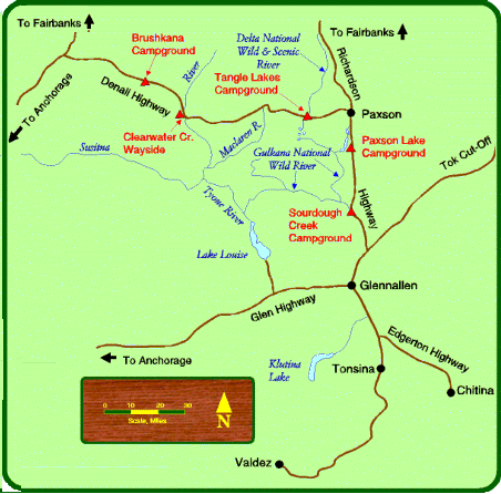
After lunch at Tangle Lake (end of the paved road), I continued on the gravel road with improving sunshine and outstanding views of Maclaren Glacier, Eureka Glacier and the Maclaren River Valley.
While I was stopped at the Maclaren River bridge taking a picture, a car passed that got a flat tire just as it crossed the bridge. I checked to see if they had a spare tire, etc. - which they did. It was a rental but I think they were driving too fast for the road conditions.
As I proceeded, up ahead of me a fellow Californian stopped, having seen a Moose. I stopped and talked with them a while. The Moose was long gone.
They were from the Riverside, CA area and he was on the Riverside Search and Rescue Team. I had also spent some time talking to a German tourist earlier in the day.
Fine views of the Susitna River Valley - broad valley with a wide river.
All of this area was alpine in nature with tundra up high and small scattered trees lower down. The views were MASSIVE over the valleys, hills and numerous ponds and lakes. Impossible to adequately photograph - just sort of absorbed it.
At another "summit" the views were great of the Alaska Range - in clearer weather can see three of the highest peaks in the Range from this spot.
This is also a divide - the Nenana River flows into the Yukon River and on to the Bering Sea, the Susitna River flows into Cook Inlet and the Pacific Ocean. Good views of the West fork and Susitna Glaciers.
, Two Bit Lake (left rear) from Denali Highway about mile 6.5")
Sevenmile Lake (foreground), Two Bit Lake (left rear) from Denali Highway about mile 6.5
, Two Bit Lake (left rear) from Denali Highway about mile 6.5")
Sevenmile Lake (foreground), Two Bit Lake (left rear) from Denali Highway about mile 6.5

Alaska Range over Sevenmile Lake from Denali Highway about mile 6.5

Ten Mile Lake, Denali Highway mile 10.1

Alaska Range over Teardrop Lake, Denali Highway mile 10.6

Sunny peak peeking over the ridge, Denali Highway

View west from Denali Highway

View south from Denali Highway

Bicyclists on Denali Highway

Bicyclists on Denali Highway

View north from Denali Highway

View from Denali Highway

View from Denali Highway

Mushroom along Denali Highway

Mushroom along Denali Highway
Viewpoint at mile 37 on the Denali Highway at an elevation of about 4,000 feet, just a short distance from the Maclaren Summit, at 4,086 feet the second highest highway summit in Alaska (the highest is Atigan Pass on the Dalton Highway). Vegetation at this elevation is low-growing alpine tundra.
Panoramic view of the Alaska Range and the Maclaren River. Mt. Hayes (13,832') and the Maclaren River and Glacier are dominant features. Aurora Peak, Mt. Shand and Mt. Geist may also be seen.
The Maclaren River flows from the Maclaren Glacier south to the Susitna River and then into Cook Inlet just west of Anchorage.

Alaska Range and Maclaren River basin with Maclaren Glacier in distant left
from Denali Highway about mile 37

Maclaren Glacier from Denali Highway about mile 37

Maclaren Glacier from Denali Highway about mile 37

Maclaren Glacier from Denali Highway at Maclaren Summit

Maclaren Glacier from Denali Highway at Maclaren Summit

Eureka Glacier? from Denali Highway at Maclaren Summit

Eureka Glacier? from Denali Highway at Maclaren Summit

Maclaren River valley from Denali Highway

Maclaren River valley from Denali Highway

Maclaren River valley from Denali Highway

Maclaren River and Glacier from Denali Highway

Maclaren River and Glacier from Denali Highway

Maclaren Glacier from Denali Highway

View from Denali Highway

Susitna River valley from Denali Highway

Susitna River valley from Denali Highway

Susitna River valley from Denali Highway

Susitna River valley from Denali Highway

Fireweed flower along Denali Highway

Fireweed flower along Denali Highway
It started to sprinkle a little as I stopped for the night at the Brushkana Creek BLM campground.
Wednesday, July 29, 1998
It rained off and on during the night and in the morning so I decided to take a layover day. The sun broke through by early afternoon but was still cloudy. I've noticed that most of the clouds in Alaska just form and stay in place - not much drifting across the sky. You also have the early morning "fog" that arises from the valleys.


