Thursday, August 22, 1996
Today is my 64th birthday. Did my laundry, resupplied and then headed up US 2 from Leavenworth to see the sights. Drove over Steven's Pass stopping at several attractions including some interesting early railroad history, then backtracked part way and drove north to Wenatchee Lake.

Tree growing in stump, Deception Falls area, North side of Stevens Pass
on US 2 west of Leavenworth, Washington

Deception Falls Creek, north side of Stevens Pass
on US 2 west of Leavenworth, Washington
Checked at the Ranger station and two of the roads to trailheads that I had wanted to use were closed by washouts. So I took the Little Wenatchee River road that WAS open and drove to the Lake Creek Campground at the end at 3000 feet.
During the night a mouse got into the car and found a package of cookies I had not opened and proceeded to work on getting inside for the goodies. I kept shaking things to scare it but it was persistent. I guess it finally left about 3 a.m..
Friday, August 23, 1996
I headed out on a day hike up the Cady Creek Trail to Cady Pass at 4300 feet in the Henry M. Jackson Wilderness. A lot of the trail was sort of overgrown with wet bushes and ferns so my legs got a bath. Nice trail otherwise.
Talked to two college age girls as I neared the pass. They were backpacking out after a several day trip.
Met the Pacific Crest Trail at the pass and headed north on it. Very nice grade and soon was out of the forest and had great views and fabulous flowers.
Saw some BIG snowy peaks to the south that I couldn't identify (not Rainier), Glacier Peak to the west, some nice peaks to the north.
High point was about 5600 feet on the slopes of Skykomish Peak, then dropped to dinky Lake Sally Ann - well beaten from campers.
Talked to a Pacific Crest Trail hiker who was doing the Washington section North to South. I mentioned the guy I had met earlier who was going the other way and he thought he had talked with him.
A half mile north of Lake Sally Ann at 5300 feet I took the Cady Ridge Trail back to the car. It climbed gently up to about 5500 feet and then stayed basically on top of the ridge for several miles before plunging down to the trailhead.
This trail is dry and steep and can be hot. It was mid-afternoon when I started on it so parts of it was in the shade. I definitely would not want to hike up it. Just after starting I met a small horse party. Later I saw a very large Owl fly from one tree to another, then fly away. Guess it though I was dangerous <grin>.
The mosquitos have not been a problem and are mostly gone; but, they are replaced by a few large horse flies and lots of small flies that are really pesky. REI's jungle juice seems to keep them at bay.
Total loop was 16 miles and a fair amount of elevation gain on mostly good trail.

Mushroom on Cady Creek Trail, Henry M. Jackson Wilderness, Washington

Mushroom on Cady Creek Trail, Henry M. Jackson Wilderness, Washington

Flowers on Pacific Crest Trail, Cady Ridge area,
William M. Jackson Wilderness, Washington

View north over Cady Ridge from Pacific Crest Trail,
William M. Jackson Wilderness, Washington

View west from Pacific Crest Trail, Cady Ridge area,
William M. Jackson Wilderness, Washington

View west from Pacific Crest Trail, Cady Ridge area,
William M. Jackson Wilderness, Washington

View south from Pacific Crest Trail, Cady Ridge area,
William M. Jackson Wilderness, Washington

View north from Pacific Crest Trail, Cady Ridge area,
William M. Jackson Wilderness, Washington

Lake Sally Ann on Pacific Crest Trail, Cady Ridge area,
Henry M. Jackson Wilderness, Washington

Glacier Peak from Pacific Crest Trail, Cady Ridge trail junction,
Henry M. Jackson Wilderness, Washington

Lake Sally Ann on Pacific Crest Trail, Cady Ridge area,
Henry M. Jackson Wilderness, Washington
Saturday, August 24, 1996
Friday night the mouse was back - maybe two of them. I finally saw it/them but couldn't do much about it. Put the cookies outside so the mouse/mice wasn't/weren't so noisy.
Saturday morning I started unloading everything to see what they had been chewing on and to try and make sure they/it were gone. Didn't find anything chewed on, but did spot one of the mice. I baited it with one of the cookies out into the open near an open door and swatted it out the door.
It landed on the ground, sat up and looked at me with its big eyes as if to say "what happened - why did you do that", then ran away. Hopefully I am now mouse free.
After a leisurely morning I headed north to the Cottonwood Campground on the Entiat River. Possible hikes into the Glacier Peak Wilderness but the possibilities didn't seem that attractive (I had planned to use trailheads that were on washed out roads south of here).
Spent the night in the nice campground and talked with the Forest Service campground host, a nice older gentlemen, retired school teacher and counselor.
Sunday, August 25, 1996
Drove back into Leavenworth, then moved on to Lake Chelan and the Lake Chelan National Recreation Area.
I was sort of turned off by what I could see via the road. After checking out the ferry fee and the parking fees if I took several days for hikes at the upper end of the lake, etc. I decided it wasn't that appealing to me. After you've seen some of these areas it's just more of the same - not that exciting. More and more I think you can't beat the Sierra.
Soooo, I moved on to Roads End campground in the Okanogan National Forest at the end of the road up the Twisp River for Sunday night. Much of this valley had also burned in 1994. Nice small free campground with campsite right next to the small river.
I took a dip in the river to cool off and wash off the crud from my last hike. It was pretty hot in the lower valleys en route here. Had the campground all to myself.
Monday, August 26, 1996
I headed up the Twisp Pass trail. About 4.5 miles to the pass with 2500 feet gain. It was smoky due to a 10,000+ acre fire north of here plus I think some from the Oregon fires. Most of the smoke was high up, but combined with a high cloud cover it made things pretty warm and the views very yucky.
The trail is pretty good but much of it was rocky (more like Sierra trails) rather than the predominantly dirt trails I had been experiencing. The upper part opens out into hillside meadows with flowers - but they were on their last legs (much drier here) so not as exciting as previous hikes. Met a couple with two young children on a day hike from their camp part way up the trail.
On top, the guide book I have suggested rambling along the ridge to the south to a small lake - a "magical spot" - I did this, nice but not magical. Also suggested rambling north along the ridge for nice views. I started out to do this but I wasn't having a real good day so ran out of energy and gave that up.
Views from the ridge into North Cascades National Park (the hike was in the Lake Chalan/Sawtooth Wilderness) were of some rugged peaks with snow and deep valleys. Trouble was, the smoke and haze made everything sort of yucky and not much for picture taking.
On the way down, met a party of four college age backpacking in for a few days. Total round trip with side trips about 10 miles.

Berries on Twisp Pass Trail, Lake Chelane-Sawtooth Wilderness west of Twisp, Washington

View west into North Cascades National Park from Twisp Pass ridge,
Lake Chelane-Sawtooth Wilderness west of Twisp, Washington

View west into North Cascades National Park from Twisp Pass ridge,
Lake Chelane-Sawtooth Wilderness west of Twisp, Washington

Lake/pond on Twisp Pass ridge,
Lake Chelane-Sawtooth Wilderness west of Twisp, Washington

Lake/pond on Twisp Pass ridge,
Lake Chelane-Sawtooth Wilderness west of Twisp, Washington

View west into North Cascades National Park from near Twisp Pass,
Lake Chelane-Sawtooth Wilderness west of Twisp, Washington

View west into North Cascades National Park from near Twisp Pass,
Lake Chelane-Sawtooth Wilderness west of Twisp, Washington
Back at camp I had neighbors. Two ladies, one from northern Washington and one from Idaho. Turned out that had both once lived in the Tahoe area and had been going camping together for years. Kept up the tradition after they moved. They had planned a backpack but with a late start decided it was too hot so car camped. They went on a day hike the next day.
Later in the evening two more ladies showed up. Talked to one of them and they are from Portland and have been driving and day hiking the North Cascade Highway. After a day hike on Tuesday they will be heading home. Everyone envies my "plan without a schedule" extended trip.
Tuesday, August 27, 1996
I laid over at this nice campsite to rest up, etc.
Wednesday, August 28, 1996
Wednesday my body didn't want to get up and go so I laid over again. Have to do that sometimes <grin>. In the process met a 21 year old from the east coast who had been living in a cabin near Estes Park in Rocky Mountain National Park after dropping out of college cause he decided he wasn't interested in the Forestry major he had started on. Was on his way to Seattle to get back in school with a more ecology/conservation agenda. While we were talking at dusk a big owl flew in and landed on a high limb above us. Guess it decided we were too large to eat.
Thursday, August 29, 1996
I stopped in Twisp to replace a bolt in the left rear shock absorber that had fallen out on one of the bumpy roads, then headed for North Cascades National Park. This web site has additional information on visiting the Park. Also here.
Stopped at the Washington Pass overlook to take pictures and admire the scenery in general. Stopped several more times along the highway for pictures.

Liberty Bell Mountain, Early Winters Sphires from Washington Pass overlook,
North Cascade Highway, Washington

Liberty Bell Mountain, Early Winters Sphires from Washington Pass overlook,
North Cascade Highway, Washington

View from Washington Pass overlook, North Cascades Highway, Washington

View from Washington Pass overlook, North Cascades Highway, Washington\

Cascading Creek & mountains from North Cascades Highway between Washington Pass
and Rainy Pass, Washington

Mt. Baker from road to Baker Lake off North Cascades Highway, Washington
Drove to Baker Lake and got one picture of Mt. Baker along the road.
Was a beautiful sunny but hazy day. The big fire near Omak was apparently out but the smoke lingered.
Getting a campsite was a little iffy as people had reserved a lot of them for the Labor Day weekend and I wasn't sure how long I was going to stay. Finally found one for the night.
Friday, August 30, 1996
At 2 a.m. when I looked out the moon was shining and the stars twinkling. At 7 a.m. when I crawled out it was cloudy. I had planned to go do a day hike on the side of Mt. Baker but it didn't look promising.
I first headed out to see Rainbow Falls (so called because it is on Rainbow Creek). Ended up in fog and clouds and rain - missed the sign for the view point and ended up at the end of a gravel road.
Would have been nice views if not cloudy. Backtracked to the falls view point. Pretty nice falls but not a very good view or photo (if it had been photo weather). Saw three deer along the road.
Then drove to the trailhead for my hike. I was late (because of getting lost on the road to the falls) but the sun was trying to break through. That didn't last though. While I was debating what to do, it POURED down rain several times. The forecast was for a sort of rainy weekend so I decided to skip this hike. Not much point in hiking in the rain if you can't see anything, etc.
Drove back to Marblemount for gas and reading material and then drove to Mineral Park Campground on Cascade River. VERY ROUGH WASHBOARD road.
Got one of the two remaining campsites. Decided to stay several days until the weather improved cause I wanted to do several hikes in the Harts Pass area.
Saturday, August 31, 1996
I laid around reading, etc. It really POURED rain.
Sunday, September 1, 1996
It sprinkled and the sun tried to come out while I holed up in the white tank.
Monday, September 2, 1996
I figured the Labor Day crowd would be going home making finding a campsite no longer a problem AND the weather appeared to be clearing.
As I drove to Marblemount it was clear over Mt. Baker area so, since I still wanted to do that hike, I headed for the Mt. Baker National Recreation Area trailhead.
It started to cloud up as I arrived but I hit the Scott Paul Trail at 10:30. Very nice trail, about 1500 foot climb to open vistas. The clouds got in the way a lot but I was able to get a few shots of Mt. Baker and the glaciers on that side (south side).
Met others doing the same thing, some in the opposite direction (it's a loop). Wierd suspension bridge over the outlet stream of one of the glaciers. Near the trailhead was another of the same design but the stream had rerouted itself (probably during the spring floods) and I had to wade a bunch of small streams as well as use the bridge.
Lots of people out picking berries (blueberries I think).
Back to the car at 3:30 (8 mile round trip). Decided to drive backup to the end of the road I had been at on Friday for a free campsite and hoping for nice views of Mt. Baker. There are nice views of the glaciers and a number of really high thin waterfalls. Clouds obscured part of it so I was hoping for sun Tuesday morning.

On Scott Paul Trail, Mt. Baker National Recreation Area, Washington

On Scott Paul Trail, Mt. Baker National Recreation Area, Washington

On Scott Paul Trail, Mt. Baker National Recreation Area, Washington

Flowers on Scott Paul Trail, Mt. Baker National Recreation Area, Washington

Flowers on Scott Paul Trail, clouds on Mt. Baker,
Mt. Baker National Recreation Area, Washington

Mt. Baker and clouds from Scott Paul Trail,
Mt. Baker National Recreation Area, Washington

Mt. Baker and clouds from Scott Paul Trail,
Mt. Baker National Recreation Area, Washington

Mt. Baker and clouds from Scott Paul Trail,
Mt. Baker National Recreation Area, Washington

Flowers on Scott Paul Trail, Mt. Baker National Recreation Area, Washington

Looking southwest from Scott Paul Trail, Mt. Baker National Recreation Area, Washington
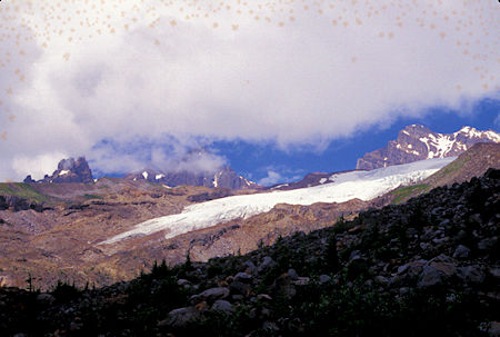
Mt. Baker and glacier from Scott Paul Trail,
Mt. Baker National Recreation Area, Washington

Mt. Baker and glacier from Scott Paul Trail,
Mt. Baker National Recreation Area, Washington

Mt. Baker and glacier from Scott Paul Trail,
Mt. Baker National Recreation Area, Washington

Mt. Baker and glacier from Scott Paul Trail,
Mt. Baker National Recreation Area, Washington

Suspension bridge on Scott Paul Trail, Mt. Baker National Recreation Area, Washington
Tuesday, September 3, 1996
During the night a storm moved in and I awoke to rain and clouds. I decided to sit it out for a while and see what happens. By noon thunder and lightning had started and some bear hunters I talked to said it was supposed to get worse.
Didn't seem like much chance of things clearing so I could see Mt. Baker and take the pictures I wanted so pulled up stakes and drove to Winthrop and a motel. In the evening the sky started to clear so I had hopes for sun the next day.
I returned in 1998 and got good pictures from this location.