

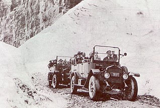
Going To The Sun Road, Circa 1930
The construction of the Going-to-the-Sun Road was a huge undertaking. Even today, visitors to the park marvel at how such a road could have been built. The final section of the Going-to-the-Sun Road, over Logan Pass, was completed in 1932 after 11 years of work.
Imagine the obstacles faced by the engineers and laborers who constructed the winding Going-to-the-Sun Road more than fifty years ago. Sheer cliffs, short construction seasons, sixty foot snow-drifts, and tons of solid rock made road building across the Continental Divide a unique challenge.
When Glacier National Park celebrated the completion of the Going-to-the-Sun Road on July 15, 1933, more than two decades of planning and construction had become a spectacular reality.
BEFORE THE ROAD
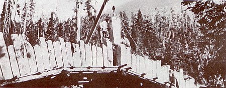
Setting the keystone at Baring Creek Bridge - National Park Service photo
taken by Bureau of Public Roads photographer, 1932
Only a few miles of rough wagon roads existed within Glacier National Park when Congress established the park on May 11, 1910. Many people, including the first Park Superintendent, William R. Logan, wanted to build a transmountain road across the park.
Supporters argued that a good road system would enable people to reach the interior of the park even if they could not afford the rates of the Great Northern Railroad and its chalets.
In addition the national enthusiasm for good roads and automobiling infected National Park Service officials as much as the rest of the country. However, some raised objections to the road.
A few local businessmen thought it would be inefficient and foolish to construct a road through the park's rugged mountains when a more dependable route could be constructed along the park's southern boundary next to the Great Northern Railroad tracks. Eventually the businessmen were convinced to support the transmountain road because of the additional tourist dollars the road would bring to their local communities. By 1921, when Congress provided the first appropriation specifically for Glacier National Park's transmountain road, the supporters of the road had clearly won the argument.
DESIGNING THE ROAD
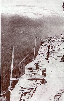
Building a retaining wall near Granite Creek - National Park Service photograph, circa 1927
The Going-to-the-Sun Road crosses Glacier National Park through Logan Pass. Various surveys in the 1910s proposed several different passes for the road, including Swiftcurrent Pass and Gunsight Pass. Other roads were proposed as well.
One surveyor planned a road completely around Lake McDonald. Another surveyor suggested a road from West Glacier, along the western shore of Lake McDonald, and up to Waterton Lake. From that main corridor, roads could spur to the left and to the right to reach almost every part of Glacier National Park.
In 1918, the first National Park Service engineer, George Goodwin, planned a route that became the guideline for transmountain road construction in the early 1920s. Goodwin's proposal was very similar to the current road except that it made a steep climb up Logan Creek using 15 switchbacks before reaching the Continental Divide at Logan Pass.
During the early 1920s Congress provided annual appropriations of $100,000 for construction of the "Transmountain Highway," as the Going-to-the-Sun Road was first called. With this money, the park signed contracts to begin construction at both ends of the road. In 1924, Glacier's appropriation increased to $1,000,000 for a three-year road construction program.
Frank A. Kittredge of the Bureau of Public Roads directed the survey of 1924. The project, which mapped out 21 miles over the Continental Divide, started in September, and Kittredge raced to finish the survey before winter closed in. Kittredge and his team of 32 men often climbed 3000 feet each morning to get to the survey sites. The crew walked along narrow ledges and hung over cliffs by ropes to take many of the measurements. The work was too challenging for some, and Kittredge's crew suffered from a 300 percent labor turnover in the three months of the survey.
Haystack Creek Culvert, one of the oldest structures along the road, was designed to blend into the natural rock surrounding it. Drawing by Jessica Gibson-Withers & Tajda Ivanisevic, Historic American Engineering Record, NPS 1990
Glacier National Park officials and Stephen Mather, the first director of the National Park Service, were extremely impressed with the work of Kittredge and the Bureau of Public Roads. In 1925, as a result of the Bureau's work on the Going-to-the-Sun Road, Mather signed an agreement with the Bureau to supervise road construction in all National Parks.
Although the Bureau of Public Roads provided the road building expertise, National Park Service landscape architects together with the Bureau's engineers created the specifications for the road, working to blend the road into the surrounding environment. They insisted that the bridges, retaining walls, and guardrails be made of native materials. Most of the structures along the road used rock excavated from the adjacent mountainsides during construction.
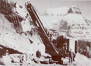
A Colonial Building Co. steam shovel east of Logan pass - National Park Service photograph, circa 1932
Another concern was with construction methods. Contractors were required to use numerous small blasts of explosives, since large blasts would cause more destruction to the landscape. It was even recommended that power shovels be excluded from construction, but since the expense of a road built exclusively with hand labor was too great, they were allowed to be used.
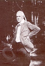
Stephen Mather, first Director of the National Park Service, was the agency's driving force for 15 years - National Park Service photograph by C.J. Kraebel, August 1924
INSPECTING THE ROAD
In August of 1924, first Director of the National Park Service Stephen Mather and Glacier National Park Superintendent Charles J. Kraebel were inspecting construction progress on the Going-to-the-Sun Road.
Two other men accompanied the Director and the Superintendent as they examined the steep approach to Logan Pass on the west side of the Continental Divide. National Park Service engineer George Goodwin had proposed a route for the Going-to-the-Sun Road which required 15 switchbacks to approach Logan Pass. Tom Vint, a National Park Service Landscape Architect opposed Goodwin's plan, so he lobbied Director Mather to approve an alternate route for the road. Vint's suggestion required only one switchback.
The group was divided in opinion, and Mather wanted a solution. As the argument continued, Mather looked at Goodwin, looked at Vint, glanced at their horses, turned and stormed off toward another appointment. By the time Vint and Goodwin assembled the horses, they never caught up with the Director.
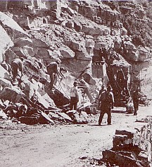
Contractors saved rock removed during excavation for use in masonry work. Sometimes they needed more rock, so they set up several quarries along the road. One quarry that was used extensively was just west of Haystack Creek. National Park Service photograph, circa 1930
Two days later Mather resolved the conflict. He enlisted the Bureau of Public Roads, and they assigned Frank A. Kittredge to survey what became the present route. Today the Going-to-the-Sun Road has only one switchback (called "the Loop") west of the Continental Divide. Tom Vint's suggestion had prevailed.
But more importantly, Mather had forged a long term agreement between the National Park Service and the Bureau of Public Roads to construct many park roads throughout the west.
BUILDING THE ROAD
After the Bureau of Public Roads and the National Park Service landscape architects completed the specifications in 1925, they accepted bids for the construction of a 12-mile section of road from Logan Creek up to Logan Pass. The Williams and Douglas construction company of Tacoma, Washington, won the contract with the low bid of $869,145 and worked on the steep west side of the road for four seasons.
Along this section of the Going-to-the-Sun Road, Williams and Douglas built most of the structures including the retaining walls, the Logan Creek Bridge, the West Side Tunnel, the Haystack Creek Culvert, and the Triple Arches. Williams and Douglas used power shovels as well as a "dinky" train--a small gasoline-powered locomotive with twelve cars-- to move excavated material to places that needed fill.
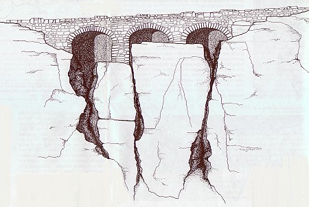
The Triple Arches was the product of an unplanned substitute for an excessively large retaining wall. The plans for the arches were worked up on site. Notice that the left arch was constructed askew. Drawing by William S. Withers, Historic American Engineering Record, NPS 1990
In 1931 and 1932, two contractors, the Colonial Building Co. of Spokane, Washington, and A.R. Guthrie of Portland, Oregon, finished the remaining ten miles of road on the east side of Logan Pass.
The most difficult construction on Colonial's contract was the 405-foot East Side Tunnel. No power equipment could reach the tunnel so laborers carried all the excavated rock out by hand.
Access was also a challenge on A.R. Guthrie's section of the road. He floated a power shovel up St. Mary Lake on a barge to reach his company's construction site.
In the late fall of 1932, after three decades of construction and more than $2,000,000, the first automobile passed over the entire 51 miles of the Going-to-the-Sun Road. Glacier National Park formally opened the Going-to-the-Sun Road in a special ceremony on July 15, 1933. Over 4000 people gathered on Logan Pass for an afternoon filled with congratulatory speeches extolling the hard work of the past 20 years.
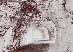
The West Side Tunnel was constructed with windows and viewing galleries from which motorists could observe Heaven's Peak. The reinforced concrete lining you see today was added during the winter of 1966-67. National Park Service photograph by Ted Marble, circa 1930
Glacier National Park Superintendent Eivind Scoyen presided over the program and read aloud messages from Secretary of the Interior Harold Ickes and National Park Service Director Horace Albright.
The chairman of the Montana State Highway Commission delivered a speech honoring the late Stephen Mather. The Civilian Conservation Corps organized a chorus, and the Blackfeet Tribal Band played the Star Spangled Banner. The afternoon ended with a ceremony of peace among the Blackfeet, Flathead, and Kootenai tribes.
In 1933 the Going-to-the-Sun Road was a complete road, but sections built before 1925 had been constructed to lower standards. Using New Deal public works funding throughout the 1930s, the park contracted to improve both the west and east sides of the road.
Until the late 1930s, the Going-to-the-Sun Road had only a crushed rock surface; however, the park started to lay an asphalt pavement in 1938. World War II interrupted the series of pavement contracts, but by the end of 1952, the road was paved in its entirety.
The first two buses over Logan Pass during the Dedication Ceremony July 15, 1933. The first automobile crossed Logan Pass the previous fall. - National Park Service photograph, 1933
NAMING THE ROAD
The road officially received its name, "The Going-to-the-Sun Road," during the 1933 dedication. The road borrowed its name from nearby Going-to-the-Sun Mountain.
Local legend, and a 1933 press release issued by the Department of the Interior, told the story of the deity, Sour Spirit, who came down from the sun to teach Blackfeet braves the rudiments of the hunt. On his way back to the sun, Sour Spirit had his image reproduced on the top of the mountain for inspiration to the Blackfeet.
An alternate story suggests a white explorer in the 1880s concocted the name and the legend. No matter which version is accurate, the road named Going-to-the-Sun still inspires all who travel it.
ALONG THE ROAD
During the road construction, access to the contractors' camps was often difficult. As a result, they built many trails and tote roads used for carrying in supplies. When building the East Side Tunnel, Colonial Building Company built a tote road on Mt. Peigan from Logan Pass to the tunnel. This tote road, about 200 feet above the Going-to-the-Sun Road, is visible from the Logan Pass Visitor Center.
The East Side Tunnel is 408 feet long and the West Side Tunnel is 192 feet long.
The retaining wall near the Golden Staircase contains 788 cubic yards of masonry.
Each contractor typically established a camp to accommodate their laborers. These camps were scattered every few miles along the road. Some of the camps were at Rising Sun, Baring Creek, Lunch Creek, the switchback just west of Logan Pass, the Loop, Logan Creek, and Avalanche Creek. A small cabin originally used by engineers is still visible on Logan Creek upstream from the road.
Notice the six percent climb between the Loop and Logan Pass. During the 1920s, a six percent grade was the maximum recommended grade because a car had to shift down to second gear at a seven percent grade.
During the 1930s reconstruction, the alignment of the Going-to-the-Sun Road changed in several places, particularly on the west side. Some of these old alignments are still visible as cuts through the forest. Look for the old alignments near Avalanche Creek, Lake McDonald Lodge, and especially between Apgar and West Glacier where there have been two previous alignments.
When preparing to blast one particularly large cliff one mile east of the Loop, the laborers wore wool socks over their boots to prevent sparks.
The contractor of the East Side Tunnel could bore 5 feet 4 inches every 24 hours.
A Caterpillar 30 tractor slipped off the road in 1931, rolled down the mountainside, and climbed back up the 200 feet with only minor damage.
Three men died during road construction.